Trail Stats
Length: 8.9 miles
Elevation Gain: 2,582 ft
Estimated Time: 5 hr 17 min
Location: Near Sperryville, Virginia
Our Experience
We always hit the road early—usually by 6:00 AM. There are a couple of good reasons for this. First, trailhead parking is limited, especially on weekends. Second, we prefer to finish our hikes by noon, giving us time to visit a local winery and unwind after a tough climb. This strategy definitely paid off on this hike.
We tackled this 8.9-mile loop, considered moderate to strenuous, and it certainly lived up to the rating. While it’s a popular trail, especially for hiking, birding, and even rock climbing, the crowds weren’t overwhelming except at the summit. The route features streamside paths, incredible vistas, and a lot of elevation gain—especially if you opt to summit Mary’s Rock.
Trail Description & Highlights
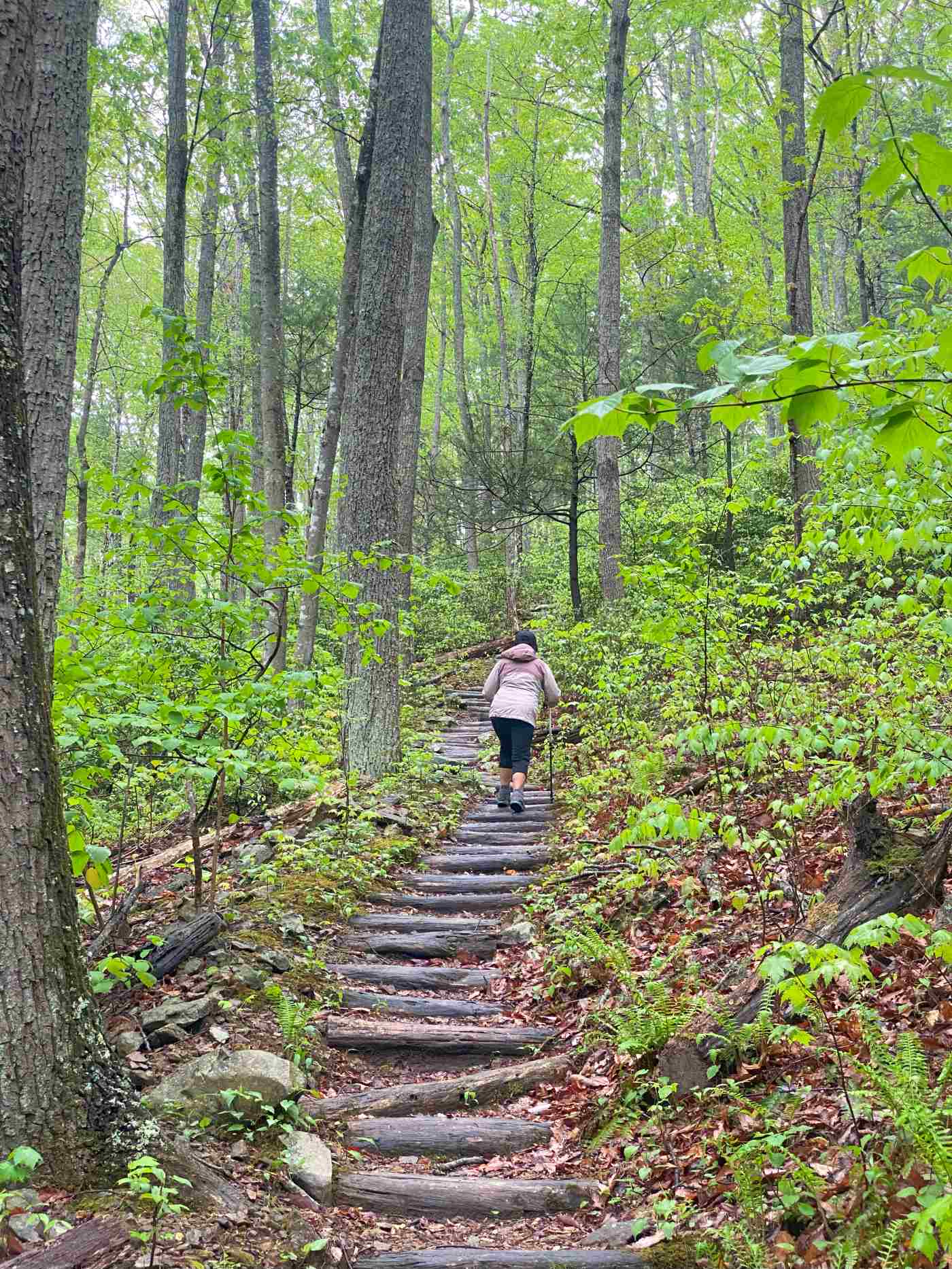
We recommend hiking the loop clockwise, starting from the parking area off Route 211. Begin by crossing a stream and turning left onto the blue-blazed Buck Ridge Trail. The first half mile is particularly intense, featuring over 660 steps and gaining about 900 feet in elevation—a tough climb that will test your legs right from the start.
After pushing through the stair-heavy ascent, you’ll pass a rock outcrop with sweeping views before reaching a T-junction. Here, go right onto the yellow-blazed Hazel Mountain Trail, leading you to the Hazel Mountain parking area on Skyline Drive.
At this point, you have two options:
Turn right onto Buck Hollow Trail to shorten the loop.
Continue to Mary’s Rock for an extended adventure.
If continuing to Mary’s Rock:
Cross Skyline Drive and head 50 yards left uphill to the Meadow Spring Trail.
Hike 0.6 miles, passing an old homestead ruin, to the Appalachian Trail (AT).
Turn right onto the AT and follow it for 0.8 miles.
At the junction with Mary’s Rock Lookout Trail, go left for the final climb to the vista. There’s a short but fun rock scramble before reaching the summit.
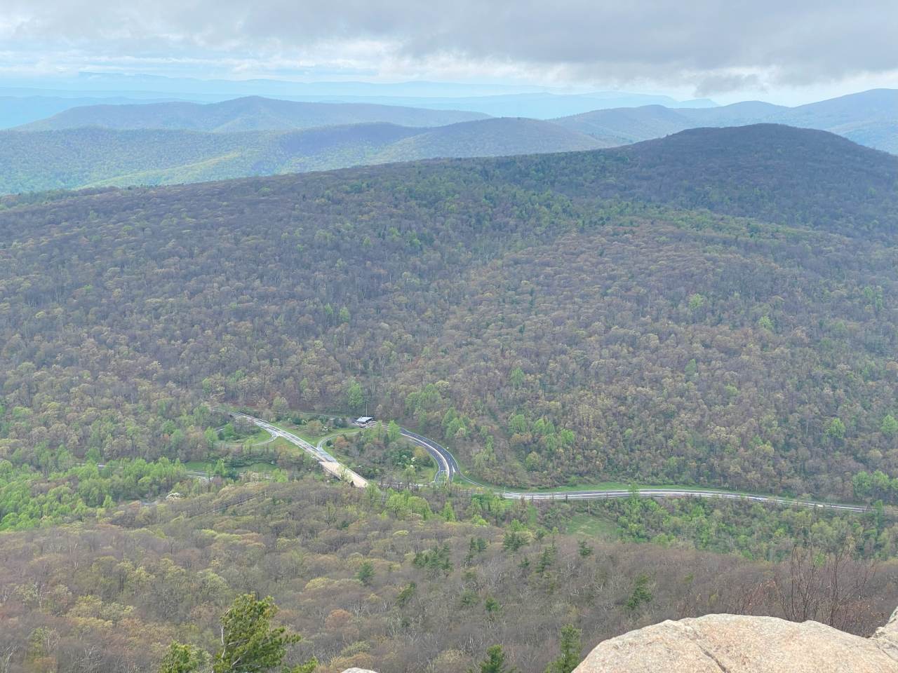
Reaching the summit of Mary’s Rock was, without a doubt, the highlight of the hike. After a steep final push and a short rock scramble, we were rewarded with panoramic views that took our breath away. From the top, we could see rolling ridgelines stretching endlessly across Shenandoah National Park, with layers of blue mountains fading into the horizon. The Skyline Drive wound like a ribbon through the valleys below, and the vast forest canopy—just beginning to green with spring—looked like an endless sea of treetops. The morning light cast a golden hue over everything, making the view feel both peaceful and powerful. It was one of those rare, still moments in nature where you can’t help but pause, take a deep breath, and soak in the beauty around you. Standing there, high above the world, it felt like time slowed down—a perfect reward for the grueling climb.
The Descent
Retrace your steps from Mary’s Rock back to the Hazel Mountain lot. Just below the parking area, turn left onto the blue-blazed Buck Hollow Trail. This trail winds down the valley, crossing the stream multiple times before intersecting with Buck Ridge Trail and leading you back to the starting point.
Final Thoughts
This loop is more difficult than Old Rag, in our opinion. The stair section at the beginning is brutal, especially on a hot, sunny day, and there were plenty of bugs—so bug spray is a must. Despite the challenges, the views, varied terrain, and peaceful stream crossings made it a highly rewarding hike. If you’re up for a workout and want a less-crowded alternative to Shenandoah’s more famous trails, this one is a gem.